In the ever-evolving realm of technology, satellite photography and sensors play a pivotal role in providing us with a unique perspective of our planet. From helping us understand climate change to assisting in urban planning, these advanced tools have revolutionized the way we view and interact with the world. In this article, we’ll delve deep into the fascinating world of satellite photography and sensors, exploring their applications, functionality, and the profound impact they have on various aspects of our lives.
Table of Contents
- Introduction
- The Evolution of Satellite Photography
- How Do Satellites Capture Images?
- Understanding Remote Sensing
- Types of Satellite Sensors
- Applications of Satellite Photography
- Environmental Monitoring
- Agriculture and Crop Management
- Disaster Management
- The Role of Satellite Sensors
- Advanced Image Processing
- Challenges in Satellite Photography
- Future Innovations
- The Influence on Everyday Life
- Conclusion
1. Introduction

Satellite photography and sensors have opened up a world of possibilities, allowing us to witness Earth’s beauty and complexity from a vantage point that was once unimaginable. This article will take you on a journey through the history, technology, and diverse applications of satellite-based imagery.
2. The Evolution of Satellite Photography
Over the decades, satellite photography has evolved from grainy, black-and-white images to high-resolution, color-rich snapshots. It all began with the launch of the first artificial satellite, Sputnik, by the Soviet Union in 1957. Since then, numerous satellites equipped with advanced imaging capabilities have been launched into orbit.
3. How Do Satellites Capture Images?
Understanding Remote Sensing
Satellites capture images through a process known as remote sensing. This involves detecting and measuring the electromagnetic radiation reflected or emitted by the Earth’s surface. Different sensors are used to capture various types of information, such as visible light, infrared, and microwave data.
Types of Satellite Sensors
There are several types of sensors onboard satellites, including optical sensors, thermal sensors, and synthetic aperture radar (SAR) sensors. Each sensor type serves a unique purpose, allowing scientists and researchers to gather data for specific applications.
4. Applications of Satellite Photography
Environmental Monitoring
Satellite imagery aids in monitoring environmental changes, including deforestation, glacial retreat, and sea-level rise. These images are invaluable for understanding the impact of climate change and devising mitigation strategies.
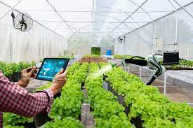
Agriculture and Crop Management
Farmers and agricultural experts use satellite data to optimize crop management. This technology provides valuable insights into soil moisture, temperature, and vegetation health, helping improve crop yields and reduce resource usage.
Disaster Management
During natural disasters such as hurricanes, wildfires, and earthquakes, satellites provide real-time information that assists in disaster response and recovery efforts. This data helps authorities make informed decisions and allocate resources effectively.
5. The Role of Satellite Sensors
Satellite sensors are the eyes of these orbiting observers. They capture data that is transmitted back to Earth for analysis and interpretation. Without these sensors, satellite photography would be incomplete and less informative.
6. Advanced Image Processing
The raw data received from satellites undergoes extensive image processing. This step enhances image quality, removes artifacts, and extracts valuable information, making the imagery more useful for various applications.
7. Challenges in Satellite Photography
While satellite photography offers numerous benefits, it also presents challenges such as cloud cover, limited revisit times, and the need for constant updates to maintain accuracy.
8. Future Innovations
The future of satellite photography and sensors holds exciting possibilities. Advancements in technology will likely lead to even higher-resolution images, more efficient data transmission, and increased global coverage.
9. The Influence on Everyday Life
From GPS navigation to weather forecasting and disaster preparedness, satellite imagery and sensors impact our daily lives in ways we may not always be aware of. These tools have become essential components of modern living.
10. Conclusion
In conclusion, satellite photography and sensors have transcended the realm of science fiction to become indispensable tools for understanding and managing our world. Their contributions to environmental conservation, agriculture, disaster management, and everyday life are immeasurable.